Change Detection
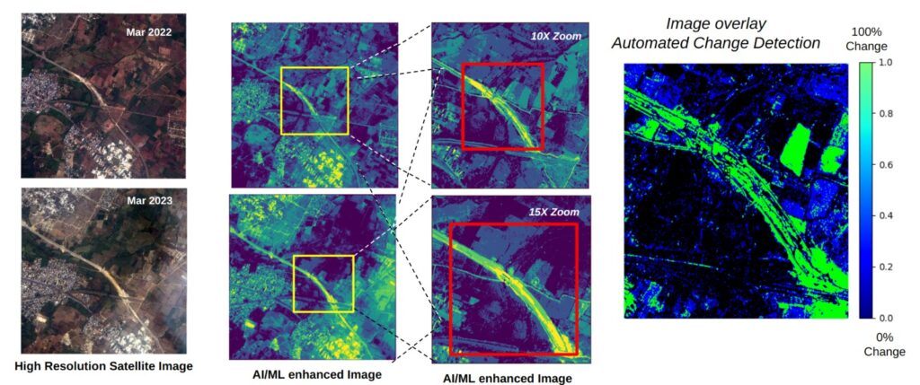
Change detection, empowered by AI/ML algorithms and the fusion of data from diverse sources, is a pivotal process for meticulously identifying and analyzing substantial shifts in the Earth’s surface and environment across time. By methodically comparing geospatial data from various epochs, it adeptly pinpoints alterations, whether stemming from natural phenomena or human activities. This dynamic tool finds critical utility in urban planning, environmental monitoring, disaster response, agriculture, and the realm of national security.
Types of Changes: Change detection can identify a wide range of changes, including urban expansion, deforestation, agricultural shifts, environmental degradation, natural disasters (e.g., wildfires, floods, and earthquakes), and security-related activities.
Use Case:
- Environmental Change Detection: Monitoring forested areas using geospatial intelligence.
- Baseline Data: Historical satellite imagery establishes a forest baseline.
- Real-time Monitoring: Continuously updated satellite data ensures timely change detection.
- Algorithmic Analysis: Change detection algorithms identify significant forest cover alterations.
- Deforestation Detection: Identifies potential deforestation and illegal logging activities.
- Habitat Loss Assessment: Evaluates wildlife habitat impact due to forest changes.
- Fire Detection: Swiftly identifies forest fires and aids in containment.
- Resource Allocation: Allocates resources for investigations and conservation efforts.
- Alert System: Automated alerts facilitate rapid response and action.
- Environmental Impact Analysis: Assesses long-term environmental trends for sustainable forest management.
- Policy and Legal Action: Supports legal actions against illegal activities and informs forest protection policies.
- Public Awareness: Share results with the public, promoting environmental awareness.